
Talaksan:Ph map siquijor.png
Walang resolusyong mataas.
Ph_map_siquijor.png ((600 × 575 pixel, laki ng talaksan: 41 KB, uri ng MIME: image/png))
|
|
Ito ay isang talaksan mula sa Wikimedia Commons. Makikita sa ibaba ang impormasyon mula sa pahina ng paglalarawan nito roon. |
This image was copied from wikipedia:tl. The original description was:
| Paglalarawan |
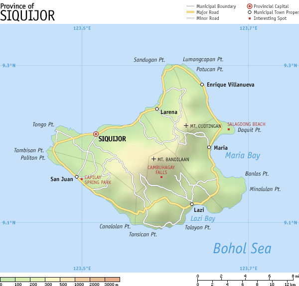
Map of en:Siquijor, en:Philippines. It is a topographic map showing the six municipalities, major and some minor roads, and notable places of interest. Created and copyright (2003) by seav. Released under the GNU FDL. |
| Petsa | 28 Hunyo 2003 (original upload date) |
| Pinanggalingan | Transferred from en.wikipedia to Commons. |
| May-akda | The original uploader was Seav at English Wikipedia. |
Paglilisensiya
| Lisensyado ang file na ito sa ilalim ng lisensiyang Creative Commons Attribution-Share Alike 3.0 Unported. Subject to disclaimers. | ||
| ||
| Ang tatak ng paglilisensiya ay idinagdag sa talaksang ito bilang bahagi ng pagsasapanahon ng paglilinsensiya ng GFDL . |

|
Pinapayagan ang pagkopya, pamamahagi, at/o pagbabago sa dokumentong ito sa ilalim ng mga nakasaad sa GNU Free Documentation License, Bersyon 1.2 o kahit anong mas bagong bersyong nilathala ng Free Software Foundation; nang walang pabago-bagong bahagi, walang teksto sa front-cover, at walang teksto sa back-cover. May nakalagay na kopya ng lisensiya sa bahaging pinamagatang GNU Free Documentation License. Subject to disclaimers. |
Tala ng orihinal na pagkarga
The original description page was here. All following user names refer to en.wikipedia.
- 2003-06-28 01:12 Seav 600×575×8 (42071 bytes) Map of [[Siquijor]], [[Philippines]].
| date/time | username | resolution | size | edit summary | |
|---|---|---|---|---|---|
| 11:04, 21 Marso 2007 | Mananaliksik | <a href="http://upload.wikimedia.org/wikipedia/tl/a/ad/Ph_map_siquijor.png"><img alt="Thumbnail for version as of 11:04, 21 Marso 2007" src="http://upload.wikimedia.org/wikipedia/tl/thumb/a/ad/Ph_map_siquijor.png/120px-Ph_map_siquijor.png" width="120" height="115" border="0" /></a> | 600×575 | 41 KB | Created and copyright (2003) by <a href="/wiki/User:Seav" title="User:Seav">seav</a>. Released under the <a href="/wiki/GNU_Free_Documentation_License" title="GNU Free Documentation License">GNU FDL</a>. {{GFDL}} |
Nakaraan ng file
Pindutin ang araw/oras upang makita kung papaano ang itsura ng talaksan noong oras na iyon.
| Araw/Oras | Thumbnail | Mga dimensiyon | tagagamit | Kumento | |
|---|---|---|---|---|---|
| ngayon | 14:41, 19 Setyembre 2008 | | 600 × 575 (41 KB) | AiraBot | This image was copied from wikipedia:tl. The original description was: {{Information |Description=Map of en:Siquijor, en:Philippines. It is a topographic map showing the six municipalities, major and some minor roads, and notable places of inte |
Mga ugnay
Nakaturo sa talaksan na ito ang mga sumusunod na mga pahina:
Pandaigdigang paggamit sa file
Ginagamit ng mga sumusunod na wiki ang file na ito:
- Paggamit sa ceb.wikipedia.org
- Paggamit sa de.wikipedia.org
- Paggamit sa es.wikipedia.org
- Paggamit sa hi.wikipedia.org
- Paggamit sa la.wikipedia.org
- Paggamit sa mk.wikipedia.org
- Paggamit sa pam.wikipedia.org
- Paggamit sa ru.wikipedia.org
- Paggamit sa simple.wikipedia.org